The texts collected here made up the contents of an early Corvus Editions pamphlet, “Elisée Reclus’ Great Globe.” I’ll undoubtedly add additional articles as I encounter them.
THE PROPOSED GIGANTIC MODEL OF THE EARTH.
ALFRED R. WALLACE
M. ELISÉE RECLUS, the well-known geographer, in a pamphlet recently printed at Brussels, [1] has elaborated a startling and even sensational proposal for the construction of a huge globe, on a scale of one hundred thousandth the actual size. This is about one-third smaller than the maps of our own one-inch Ordnance Survey; and the magnitude of the work will be appreciated when it is stated that the structure will be 418 feet in diameter, so that the London Monument, if erected inside it, would not reach to its centre, while even the top of the cross of St. Paul’s Cathedral would fall short of its North Pole by fourteen feet. This enormous size is considered to be necessary in order to allow of the surface being modelled with minute accuracy and in true proportions, so as to show mountains and valleys, plateaux and lowlands, in their actual relations to the earth’s magnitude. Even on this large scale the Himalayas would be only about three and a half inches high, Mont Blanc about two inches, the Grampians half an inch, while Hampstead and Highgate would be about one-sixteenth of an inch above the valley of the Thames. It may be thought that these small elevations would be quite imperceptible on the vast extent of a globe which would be a quarter of a mile in circumference; but the visibility of inequalities of surface depends not on their actual magnitude so much as on their steepness or abruptness, and most hills and mountains rise with considerable abruptness from nearly level plains. All irregularities of surface are appreciated by us owing to the effects of light and shade produced by them; and by a proper arrangement of the illumination the smallest deviations from a plane can be easily rendered visible. Again, the slopes of mountains are always much broken up by deep valleys, narrow gorges, or ranges of precipitous cliffs, which give a distinct character to mountainous countries, thus producing striking contrasts with lowlands and plateaux, which, when brightened by appropriate colouring and brought to view by a suitable disposition of the sources of light, would give them any desired amount of distinctness.
It is proposed that the globe shall always be kept up to the latest knowledge of the day, by adding fresh details from the results of new -explorations in every part of the world; so that, by means of photography, maps of any country or district could be formed on any scale desired; and for a small fee the globe might be available to all map-makers for that purpose. Such maps would be more accurate than those drawn by any method of projection, while the facility of their construction would render them very cheap, and would thus be a great boon to the public, especially whenever attention was directed to any particular area.
M. Reclus states the scientific and educational value of such a globe as due to the following considerations—(1) its accuracy of proportion in every part, as compared with all our usual maps, especially such as represent continents or other large areas; (2) the unity of presentation of all countries, by which the erroneous ideas arising from the better known countries being always given on the largest scale will be avoided; and (3), that the true proportions of all the elevations of the surface will be made visible, and thus many erroneous ideas as to the origin, nature, and general features of mountain ranges, of valleys, and of plateaux will be corrected. He has fixed upon the scale of one hundred thousandth for several reasons. In the first place, it gives the maximum size of a globe that, in the present state of engineering science, can probably be constructed, or that would be in any case advisable; secondly, it is the scale of a considerable number of important maps in various parts of the world; and, thirdly, it is the smallest that would allow of very moderate elevations being modelled on a true scale. He considers that even Montmartre at Paris and Primrose Hill at London would be distinctly visible upon it under a proper oblique illumination.
When, however, we consider the size of such a globe, nearly four hundred and twenty feet in diameter, it is evident that both the difficulties and the cost of its construction will be very great; and both are rendered still greater by the particular design adopted by M. Reclus—a design which, in the opinion of the present writer is by no means the best calculated to secure the various objects aimed at. I will therefore first briefly describe the exact proposals of M. Reclus as set forth in his interesting and suggestive pamphlet, and will then describe the alternative method, which seems to me to be at once simpler, less costly, and more likely to be both popular and instructive.
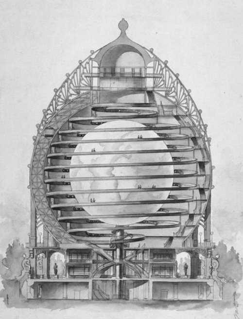
The essential features of the proposed globe are said to be as follows. Nothing about it must destroy or even diminish its general effect. It must not therefore rest upon the level ground, but must be supported on some kind of pedestal; and it must be so situated as to be seen from a considerable distance in every direction without any intervening obstruction by houses, trees, &c. But, in our northern climate, the effects of frost and snow, sun and wind, dust and smoke, rain and hail, would soon destroy any such delicate work as the modelling and tinting of the globe; it is therefore necessary to protect it with an outer covering, which will also be globular, its smooth outer surface being boldly and permanently coloured to represent all the great geographical features of the earth, so as to form an effective picture at a considerable distance. In order to allow room for the various stairs and platforms which will be required in order to provide for access to every part of the surface of the interior globe, and to afford the means of obtaining a view of a considerable extent of it, there is to be a space of about fifty feet between it and its covering, so that the latter must have an inside diameter of about five hundred and twenty feet. It is also to be raised about sixty feet above the ground, so that the total altitude of the structure will be not far short of six hundred feet.
M. Reclus adds to his general description a statement furnished by a competent engineer giving a general estimate for the erection of the globe, with some further constructive details, which are, briefly, as follows: Both the globe and the envelope are to be built up of iron meridians connected by spiral bands, leaving apertures nowhere more than two metres wide. The envelope is to be covered with thick plates of glass, and either painted outside on a slightly roughened surface, or inside with the surface remaining polished, either of which methods are stated to have certain advantages with corresponding disadvantages. The envelope being exposed to storms and offering such an enormous surface to the wind would not be safe on a single pedestal. It is therefore proposed to have four supports placed about 140 feet apart, and built of masonry to the required height of 6’0 feet. The globe itself is to have a surface of plaster, on which all the details are to be modelled and tinted, the oceans alone being covered with thin glass. In order to provide access to every part of the surface of the globe it is proposed to construct in the space between the globe and its covering, but much nearer to the former, a broad platform, ascending spirally from the South to the North Pole in twenty-four spires, with a maximum rise of one in twenty. The balustrade on the inner side of this ascending platform is to be one metre (3 feet 3 inches) from the surface of the globe, and the total length of the walk along it will be about five miles. But as the successive turns of this spiral pathway would be about 20 feet above each other, the greater part of the globe’s surface would be at too great a distance, and would be seen too obliquely, to permit of the details being well seen. It is therefore proposed that the globe should rotate on its polar axis, by which means every part of the surface would be accessible, by choosing the proper point on the platform and waiting till the rotation brought the place in question opposite the observer. But as such an enormous mass could only be rotated very slowly, and even more slowly brought to rest, this process would evidently involve much delay and considerable cost Again, as the facility of producing accurate maps by photography is one of the most important uses which the globe would serve, it is clear that the spiral platform, with its balustrade and supporting columns, would interfere with the view of any considerable portion of the surface. To obviate this difficulty it is stated that arrangements will be made by which every portion of the spiral platform may be easily raised up or displaced, so as to leave a considerable portion of the globe’s surface open to view without any intervening obstruction. In order that this removal of a portion of the roadway may not shut off access to all parts of the globe above the opening, eight separate staircases are to be provided by means of which the ascent from the bottom to the top of the globe may be made.
This account of the great earth-model proposed by M. Reclus clearly indicates the difficulties and complexities in the way of its realisation. We are required to erect, not one globe, but two, the outer one, to serve mainly as a cover for the real globe, being very much larger, and therefore much more costly, than the globe itself. Then we have the eight staircases of twenty-four Sights each, and the five or six miles of spiral platform, wide enough to allow of a pathway next the surface of the globe and a double line of road outside for the passage of some form of auto-motor carriages. Then, again, the greater part of this huge spiral platform is to be in movable sections, which can be either swung aside or lifted up in order to allow of an uninterrupted view of any desired portion of the globe’s surface. But even this will not suffice to get an adequate view of the globe in all its parts, and this enormous mass is to be rendered capable of rotating on a vertical axis. It is suggested that this rotation shall be continuous in the space of a sidereal day, and it is thought that it will be so slow as not to interfere with any photographic operations that may be desired.
But a little consideration will show us that, even with all these complex constructions and movements, and supposing that they all work with complete success, the main purposes and uses of the globe, as laid down by M. Reclus himself, would be very imperfectly attained. His first point is that such a globe would correct erroneous ideas as- to the comparative size and shape of different regions due to the use of Mercator’s or other forms of projection. But in the globe as proposed no comparison of different countries, unless very near together, would be possible; and even if considerable portions of the platform could be removed, and the observer could be placed near the outer covering, at a distance of, say, 40 feet from the globe, only a comparatively small area could be seen or photographed in its accurate proportions. If we take a circle of 40 feet diameter as our field of view it is evident that all the marginal portion would be seen very obliquely (at an angle of 30° from the perpendicular if the surface were flat, but at a somewhat greater angle owing to the curvature of the surface), and would also be on a smaller scale owing to their greater distance from the instrument, so that the central portions only would be seen in their true proportionate size and shape. For ordinary views this would not much matter, but when we have to produce maps from a globe which is estimated to cost somewhere about a million sterling, and one of whose chief uses is to facilitate the production of such maps, a high degree of accuracy is of the first importance. In order to attain even a fair amount of accuracy comparable with that of a map on any good projection, we should probably have to limit the area to a diameter of about 10 feet, equal to about 190 or 200 miles, so that even such very limited areas as Scotland 6r Ireland would be beyond the limits of any high degree of accuracy. Larger areas, such as the British Isles, France, or Germany, would be quite beyond the reach of any accurate reduction by means of photography. As affording exceptional facilities for accurate map-making’ the globe would be of very limited service.
The second advantage to be derived from the proposed globe is stated to be the correction of erroneous ideas as to the comparative sizes of various countries and islands, owing to the fact of their representation in atlases on very different scales, while each country gives its own territories the greatest prominence. But a large part of this advantage would be lost owing to the fact that distant countries could never be seen together. That Texas is much larger than France would not be impressed upon the spectator when, after losing sight of the one country several hours might pass before he came in sight of the other, while even the various States of Europe, such as Great Britain and Italy, or Portugal and Turkey, would never be in view at the same time. For this special purpose, therefore, the globe would not be so instructive as the ‘large wall maps of continents at present need in every schoolroom.
The third advantage, that the globe would admit of the varied contours of the surface being shown in their true proportions, does undoubtedly exist, and is very important; but even as regards this feature, its instructiveness would be very largely diminished by the impossibility of seeing the contours of any considerable area in its entirety, or of comparing the various mountain ranges with each other, or even the different parts of the same mountain range. It may be doubted whether the relief-maps now made do not give as useful information as would be derived from a globe of which only so limited a portion could be seen at one view.
It thus appears that the gigantic earth-model proposed by M. Reclus would very imperfectly fulfil the purposes for which he advocates its construction. But this defect is not at all inherent in a globe of the dimensions he proposes, but only in the particular form of it which he appears to consider to be alone worthy of consideration. I believe that such a globe can be made which shall comply with the essential conditions he has laid down, which shall be in the highest degree scientific and educational, which shall be a far more attractive exhibition than one upon his plan, and which could be constructed for about one-third the amount which his double globe would cost. It would only be necessary to erect one globe, the outer surface of which would present a general view of all the great geographical features of the earth, while on the inner surface would be formed that strictly accurate model which M. Reclus considers would justify the expense of such a great work, and which, as I shall presently show, would possess all those qualities which he postulates as essential, but which the globe described by him would certainly not possess.
I make no doubt that the eminent geographer would at once put his veto upon this proposal as being wholly unscientific, unnatural, and absurd. He would probably say that to represent a convex body by means of a concave surface is to turn the world upside-down, or rather outside-in, and is fundamentally erroneous; that it must lead to false ideas as to the real nature of the earth’s surface, and that it cannot be truly educational or scientifically useful. But these objections, and any others of like nature, are, I venture to think, either unsound in themselves or are wholly beside the question at issue. M. Reclus has himself declared the objects of the gigantic earth-model and the educational and scientific uses it should fulfil. I take these exactly as he has stated them, and I maintain that if the plan proposed by me can be shown to fulfil all these requirements, then it can not be said to be less scientific, or less instructive, than one which can only fulfil them in a very inferior degree.
Before showing the overwhelming advantages of the concave over the convex globe for all important uses, I would call attention to two strictly illustrative facts. Celestial globes have been long in use, and I am not aware that it has ever been suggested that they are unscientific and deceptive, and they ought to be abolished. Positions seen on such a globe can be, and are, easily transferred to the apparently concave sky; while many problems relating to the motions the earth and the planets are clearly illustrated and explained by their use. A concave surface suspended from the ceiling of a schoolroom would, doubtless, show more accurately the position of the heavenly bodies, but would probably not be so generally useful as the unnatural convex globe.
The representation of the earth’s surface on the inside of a sphere has been tried on a considerable scale by Wyld’s globe in Leicester Square, and was found to be extremely interesting and instructive. Before seeing it I was prejudiced against it as being quite opposed to nature; but all my objections vanished when I entered the building and beheld the beautiful map-panorama from the central gallery. I visited it several times, and I never met with any one who was not delighted with it, or who did not find it most instructive in correcting the erroneous views produced by the usual maps and atlases. It remained for twelve years one of the most interesting exhibitions in London, when it was removed owing to the lease of the ground having expired. This globe was sixty feet in diameter, and it showed how grand would be the effect of one many times larger and admitting of greater detail, and of more striking effects by the view at different distances and under various kinds of illumination.
One other consideration may be adduced in this connection, which is, that even the outer surface of a huge globe has its own sources of error and misconception. It would perpetuate the idea of the North pole being up and the South-pole down, of the surface of the earth being not only convex but sloping, while for the whole southern hemisphere we should have to look upwards to see the surface, which we could never do in reality unless we were far away from that surface. Again, we all know how the sea-horizon seen from an elevation appears not convex but concave. A convex globe, therefore, will not represent the earth as we see it, or as we can possibly see it; and to construct such a globe with all the details of its surface clearly manifest, while at the same time we see the convexity and have to look up to some parts of the surface and down upon others, really introduces fresh misconceptions while getting rid of old ones. We cannot reproduce in a model all the characteristics of the globe we live on, and must therefore be content with that mode of representation which will offer the greater number of advantages and be, on the whole, the most instructive and the most generally useful. This, I believe, is undoubtedly the hollow globe, in which, however, the outer surface would be utilised to give a general representation of the earth as proposed by M. Reclus, and which would no doubt be a very interesting and attractive object.
I will now proceed to show, in some detail, how the concave surface of a hollow globe is adapted to fulfil all the purposes and uses which M. Reclus desires.
We should, in the first place, be able to see the most distant regions in their true relative proportions with a facility of comparison unattainable in any other way, We could, for instance, take in at one glance Scandinavia and Britain, or Greenland and Florida, and by a mere turn of the head could compare any two areas is a whole hemisphere. Both the relative shape and the relative size of any two countries or islands could be readily and accurately compared, and no illusion as to the comparative magnitude of our own land would be possible. In the next place, the relief of the surface would be represented exactly as if the surface were convex, but facilities for bringing out all the details of the relief by suitable illumination would be immensely greater in the hollow globe. Instead of being, obliged to have the source of illumination only fifty feet from the surface, it could be placed either at the pole or opposite the equator at a distance of two hundred or three hundred feet, and be easily changed so as to illuminate a particular region at any angle desired, and to render visible the gentlest undulations by their shadows. Of course, electric lighting would be employed, which by passing through slightly tinted media might be made to represent morning, noon, or evening illumination.
It is, however, when we come to the chief scientific and, educational use of such a globe, the supply of maps of any portion of the earth on any scale, by means of photography, that the superiority of the concave model is so overwhelming as to render all theoretical objections to it entirely valueless. We have seen that on the convex surface of a globe such as M. Reclus has proposed, photographic reproductions of small portions only would be possible, while in areas of the size of any important European State, the errors due to the greater distance and the oblique view of the lateral portions would cause the maps thus produced to be of no scientific value. But, in the case of the concave inner surface of a sphere, the reverse is the case, the curvature itself ‘being an essential condition of the very close accuracy of the photographic reproduction. A photograph taken from anywhere near the centre of the sphere would have every portion of the surface at right angles to the line of sight, and also at an equal distance from the camera. Hence there would be no distortion due to obliquity of the lateral portions, or errors of proportion owing to varying distances from the lens. We have, in fact, in a hollow sphere with the camera placed in the centre, the ideal conditions which alone render it possible to reproduce detailed maps on the surface of a sphere with accuracy of scale over the whole area. For producing maps of countries of considerable extent the camera would, therefore, be placed near the centre, but for maps of smaller areas on a larger scale, it might be brought much nearer without any perceptible error being introduced, while even at the smallest distances and the largest scale the distortion would always be less than if taken from a convex surface. It follows that only on a concave globular surface would it be worth the expense of modelling the earth in relief with the greatest ‘attainable accuracy, and keeping it always abreast of the knowledge of the day, since only in this way could accurate photographic reproductions of any portions of it be readily obtained. For absolute accuracy of reduction the sensitive surface would have to be correspondingly concave, and this condition could probably be attained.
I will now point out how much more easily access can be provided to every part of the surface of a concave than to that of a convex globe. Of course, there must be a tower in the position of the polar axis. This would be as small in diameter as possible consistent with stability, and with affording space for a central lift; and it would be provided with a series of outside galleries supported on slender columns, at regular intervals, for affording views of the whole surface of the globe. This general inspection might be supplemented by binocular glasses with large fields of view and of varying powers, by means of which all the details of particular districts could be examined. For most visitors this would be sufficient; but access to the surface itself would be required, both- for purposes of work upon it, for photographing limited areas at moderate distances, and for close study of details for special purposes. This might be provided without any permanent occupation of the space between the central tower and the modelled surface, in the following manner.
Outside the tower and close to it will be fixed, at equal distances apart, a series of three or four circular rails, on which will rest by means of suitable projections and rollers, two vertical steel cylinders, exactly opposite to each other and reaching to within about ten feet of the top and bottom of the globe, with suitable means of causing them slowly to revolve. Attached to these will be two light drawbridges, which can be raised or depressed at will, and also, when extended, will have a vertical sliding motion from the bottom to the top of the upright supports. The main body of this drawbridge would reach somewhat beyond the middle point from the tower to the globular surface, the remaining distance being spanned by a lighter extension sliding out from beneath the main bridge and supported by separate stays from the top of the tower. When not in use, the outer half would be drawn back and the whole construction raised up vertically against the tower. The two bridges being opposite each other, and always being extended together, would exert no lateral strain upon the tower.
By means of this arrangement, which when not in use would leave
the whole surface of the globe open to view, access could be had to every square foot of the surface, whether for purposes of work upon it or for close examination of its details; and, in comparison with the elaborate and costly system of access to the outer surface of a globe of equal size, involving about five miles of spirally ascending platform and more than a mile of stairs, besides the rotation of the huge globe itself, is so simple that its cost would certainly not be one-twentieth part of the other system. At the same time, it would give access to any part of the surface far more rapidly, and even when in use would only obstruct the view of a very small fraction of the surface.
A few words may be added as to a mode of construction of the globe different from that suggested in the project of M. Reclus. It seems to me that simplicity and economy would be ensured by forming the globe of equal hexagonal coils of cast steel of such dimensions and form that when bolted together they would build up a perfect sphere of the size required. As the weight and strain upon the material would decrease from the bottom to the top, the thickness of the walls of the cells and of the requisite cross struts might diminish in due proportion while the outside dimensions of all the cells were exactly alike. At the equator, and perhaps at one or two points below it, the globe might be encircled by broad steel belts to resist any deformation from the weight above. A very important matter, not mentioned by M. Reclus, would be the maintenance of a nearly uniform temperature, so as to avoid injury to the modelling of the interior by expansion and contraction. This might be secured by enclosing the globe in a thick outer covering of silicate or asbestos packing, or other non-conducting material, over which might be formed a smooth surface of some suitable cement, on which the broad geographical features of the earth might be permanently delineated. With a sufficiency of hot-water pipes in and around the central tower, and efficient arrangements for ventilation, the whole structure might be kept at a nearly uniform temperature at all seasons.
It has now, I think, been shown that the only form of globe worth erecting on a large scale is one of which the inner surface is utilised for the detailed representation and accurate modelling of the geographical features of the earth’s surface; but as to the dimensions of such a globe there is room for much difference of opinion. I am myself disposed to think that the scale of 1/100000, proposed by M. Reclus, is much too large, and that for every scientific and educational purpose, and even as a popular exhibition, half that scale would be ample. The representation of minute details of topography due to human agency, and therefore both liable to change and of no scientific importance—such as roads, paths, houses, and enclosures—would be out of place on such a globe, except that towns and villages and main lines of communication might be unobtrusively indicated. And for adequately exhibiting every important physiographical feature—the varied undulations of the surface in all their modifications of character, rivers and streams with their cascades and rapids, their gorges and alluvial plains, lakes and tarns, swamps and peat-bogs, woods, forests, and scattered woodlands, pastures, sand dunes and deserts, and every other feature which characterizes the earth’s surface, a scale of 1/200000th, or even one of 1/250000th, would be quite sufficient. And when we consider the difficulty and expense of constructing any such globe, and the certainty that the experience gained during the first attempt would lead to improved methods should a larger one be deemed advisable, there can, I think, be little doubt that the smaller scale here suggested should be adopted. This would give an internal diameter of 167 feet, and a scale of almost exactly a quarter of an inch to a mile, and would combine grandeur of general effect, scientific accuracy, and educational importance, with a comparative economy and facility of construction which would greatly tend to its realisation. It is with the hope of showing the importance and practicability of such a work that I have ventured to lay before the public this modification of the proposal of M. Reclus, to whom belongs the merit of the first suggestion and publication. Now that Great Wheels and Eiffel Towers are constructed, and are found to pay, it is to be hoped that a scheme like this, which in addition to possessing the attractions of novelty and grandeur, would be also a great educational instrument, may be thought worthy of the attention both of the scientific and the commercial world.
Alfred E. Wallace.
A GREAT GLOBE.
By Professor ELISÉE RECLUS. [2]
Recently being in conversation here in London with a traveller and discoverer, I mentioned the great geographical importance of accurate representations of our planet in the shape of globes; suddenly he interrupted me, and said with a smile, “What is the use of your Lilliputian globes, ten, a hundred, or a thousand yards thick, when you have the very globe itself, our good and beneficent Earth, to walk over, to look at, to study, and to love?” Of course I laughed, and thought with him that all representations and symbols of life are very little in comparison with life itself: our works are small when contrasted with nature. But the great man who thus spoke in joke knew as well as I do, the value of scrupulous effects in geographical work. He has himself drawn very useful maps, which enable us to follow him in his great travels. We cannot all perambulate the surface of our planer, but we may still be very useful in a secondary way. The great question is to know in what direction we are to exert ourselves in order to produce the greatest amount of perfect scientific labour. The chosen few will make discoveries; the others, less fortunate, but happy still, will follow in the track opened to them.
One of our eminent geographers, who is present at this meeting, Dr. Hugh Robert Mill, gave us, a few years ago, a lecture on the “Geographical Work of the Future,” and put great stress on this, that “accurate cartographic representation is the very essence of geography.” Certainly he was right. Accuracy of design is of paramount importance, and this is the reason why geodesists measure the surface of the Earth with such wonderful care and precision: a difference of a few millimetres on two measurements of a line of base is justly a great matter of discussion, and obliges the scientific bodies to begin the work again. Thus a perfect exactitude is obtained in geodetic calculations, and the real distances and proportions of all geographical features are triumphantly made out; but the results, although fulfilling all expectations and perfect in registers and tables, are in a certain measure practically lost on the deceitful maps and charts: there truthful representation is quite out of the question, at least for all parts of the figure which are not delineated on the centre of the map. A plane surface never will nor can be the real representation of a spherical surface. Splendid devices may be imagined by the mathematicians to lessen the importance of errors according to this or that dimension of the map, but although I do not deny the immense conveniency of maps, without which there would be no geography at all, still we may point out the errors which will subsist, and sometimes we feel tempted to ask, “What’s the use of having secured perfect accuracy in measurement, within one millimetre, when on paper the errors must amount to yards, furlongs, and miles?”
There is only one way to represent truly the surface of the Earth. Curves are to be translated in curves; a sphere or fragment of a sphere must be reproduced by another sphere or fragment of sphere. Therefore are we really astonished that public attention and the special care of geographers are so little attracted towards this logical mode of geographical work.
The progress of cartography proper has been really immense. When we compare the maps and charts which are now constructed by the various industrial, maritime, and military staffs with the very interesting maps of the last century, which had been also constructed with great care by the best geographers and at very great expense, we are struck by the marvellous increase of those documents, not only in quantity, but also in quality. I may say that certain maps, where the scale is very large, and which, in fact, may be considered part of an immense globe, are at the same time so gloriously embellished by colours and graduated tints that they are really wonderful to look at, both as true representations of nature and as marvellous works of art. The impression which genuine geographers feel is very near or even entirely similar to that of an artist before a glorious picture or statue. To see nature itself, and to behold at the same time a picture of it in perfect accordance with the reality, is positively a rapture. As examples, there are the official maps of Switzerland or the Bay of Naples.
But, returning to sphærography, we must avow that there are very few globes or segments of globes which have been made with sufficient care to be held in comparison with the best charts. Generally they are much less scrupulously drawn, being constructed more for show than for science; they are less worthy of attention. Of course, some of the elaborate globes which have been issued by various publishers are altogether very creditable objects, but few are to be studied with the same confidence as maps in almost all civilized countries. Some of the globes which have been constructed are huge in dimensions. There is one cut in a rock, I believe, on the seashore near Bournemouth, but I don’t know if it has any real value. There was one at the last Paris Exhibition which was some 120 feet in circumference, being one-millionth of the mother Earth to scale, and I must say this gigantic globe has left on minds of the three hundred thousand people who saw it a very deep impression, by the mere comparison of dry land and sea, and the large proportions of countries which are ordinarily shown in Lilliputian forms in most atlases. I remember, also, the real feeling of rapture which pervaded me when, in my youth, I walked inside of Wylde’s globe, near this very place, admiring the magnificent sight. But that noble structure, as well as the Paris Exhibition globe, made no pretence to accuracy in geography proper; they had been designed only to be looked at from afar, without any special study of minor details.
The Paris globe was to be seen from the outside, on a winding staircase; the London Wylde’s globe, forgotten now by our contemporaries, was seen from the inside, and was to be contemplated at one circular glance. According to Alfred Russel Wallace, whose opinion has such great weight, the last method would be really the best.
I repeat it again, this department of geography, sphærography, although the most important to develop, has not kept pace with the other, cartography, and I presume it will be a real revolution when it has taken in science and practice the paramount place it deserves. At present small globes are very much in use for schools, but we know how that part of the educational furniture is shamefully neglected; the very fact that it is found in elementary classes is one cause of the disdain in which globes are generally held. There is, perhaps, another reason. Globes of large proportions are very cumbrous objects, and in our crowded cities, where space is so expensive, it is very difficult to find place for these scientific guests. And, above all, the best of reasons is that education has not been yet directed in that way, and people, even scientific people, are not yet sufficiently convinced of the absolute necessity there is to study geography on images of our planet reduced to a commodious scale and with the real proportions. There is no geographer, however learned and accustomed to the reading of maps, who is not constantly at a loss to understand immediately, at the sight of charts drawn on all kinds of scales, what exact proportions the country represented bears to his own land or district. He will not see the real state of things; he will try to remember the figures he has learnt by heart, or make tedious calculations, which are a great loss of time.
So it is that for us all, learned or unlearned, the direct study of geography on spherical surfaces is absolutely necessary. If the scale of the globe is very small in comparison to the real dimensions; if it is, for example, in the proportion of only one to 10 or 20 million, then the surface is to be kept even—polished, we may say—because the roughness of the highlands and mountains cannot be represented with sufficient relief. On such a ball, 6 or 12 feet in circumference, the highest mountain of Himalaya would not represent 1/25th of an inch in height, and the ordinary hills would hardly alter the regular surface of the globe. But, with larger spheres or fragments of spheres, another element of truth and beauty is added to the construction; the actual relief appears on the curvature of the model.
And here allow me to say, once for all, that the system of exaggerating the proportional height of hills and mountains on the surface of globes is utterly bad, contrary to real science, and ought to be discouraged by all geographers respectful of nature and its laws. In that way the utmost ugliness is attained; people who do that kind of work seem to think themselves above all sense of reality. Thus we hear that the ladies of the Philippine islands, wishing to make a valuable present, imagined to have a representation of their archipelago made by a jeweller with rubies for the cities, sapphires for lakes, and other costly stones for volcanoes. Of course, many thousand pounds were expended for that miserable rubbish.
All the pseudo-relief maps which show us slopes with two, three, fifty, one hundred times their real proportions in height, inconsistent with the facts, and violating the forces of gravitation, are the logical consequence of a childish desire to represent grand sights as if they were always stupendous, wonderful, next to miraculous. It is in the same spirit that, during the first part of this century, before the invention of photography, painters were prone to exaggerate in their pictures twice, or even three times, the real proportions of mountains in altitude; conscious in a certain measure of the deficiency of their art, they relied on falsehood to make it more eloquent. Happily, new discoveries have enrolled the sure, the victorious light of the sun on the side of truth, and now we have by thousands and by millions splendid pictures of mountains, which give to our eyes the true sense of proportion, and certainly do not diminish our conception of beauty.
The revolution which photography has accomplished in pictorial art is to be achieved also in relief construction. We are to be most strict in one thing— keep always to the truth. It is the best plan in scientific work as in life. Truth in scales: therefore it is that we must use globes instead of maps as frequently as possible. Truth in heights of relief: therefore do we leave entirely out of question the idea of showing any apparent roughness on globes or fragments of globes under the scale of one-millionth. On such balls colours and shades only will be convenient to represent the various altitudes on the Earth and depths in the sea.
But as soon as the globe or fragment of globe is large enough to show at least one-millionth part of the Earth in real proportions, then we may try to represent as well the heights and depths as the planimetric dimensions. Of course, the chiselling and moulding of the surface will be more and more elaborate in proportion to the increase of the scale. On a globe of one-millionth, the great masses of highlands and mountains, 3000 feet in height, will hardly appear above the plains, and only by the contrast of light and shade; but summits of 10,000 or 12,000 feet will be seen perfectly well—the more so, that to show forests, pastures, snow or ice, various colours and tints will heighten the effect as they do in reality. It the size in diameter be doubled, the impression of the sight is increased, and the relief is represented with much greater accuracy. If you construct a very large globe on the scale of 1 to 100,000, then all the details of elevation and depth will appear most distinctly, even hills and hillocks 150 feet in height. You see the very Earth as if you were sailing above it in a balloon. The representation of such heights, whose appearance our eyes are accustomed to, gives us an unexpected advantage by furnishing us with a standard of comparison. To give us an idea of the real height of a building, photography and painters put men or women standing all around or leaning against the pillars. Thus spectators of a relief will easily estimate, by comparison with known heights, the real dimensions of the hills and mountains which diversify the surface.
There has been in Switzerland lately a very interesting public controversy. A skilful cartographer and relief maker (M. Charles Perron) had proposed to (he Federal Council to construct, for the Paris Exhibition, a relief of Switzerland on the scale of 1 to 100,000, which, he said, would do honour to the country; and, indeed, the samples of the work which he exhibited at Bern and Geneva excited general admiration. Evidently the undertaking deserved to be encouraged, and it would have been taken under the official patronage of the Swiss Republic if a few influential geodesists bad not interfered, asserting that a true and perfectly detailed representation of nature wanted a larger scale than the 100,000th. As in examples of their contention, they referred to the parting of slopes on nearly horizontal ground; the geographical changes brought in the configuration of a valley by the advance of a morainic ridge; the displacement of the courses of rivers caused by landslips and erosions—all facts of small magnitude in their origin, hut of great geographical importance, and which are to be fully represented on largo relief to be clearly understood. Pamphlets and articles were published on both sides, and the question was fully elucidated by most competent scholars.
Now we may resume the discussion. According to the effect which must be attained, and the elaborate study which is aimed at, scales must be different in globes, as also they are in all other modes of representation, maps, charts, and plans.
If our intention is to show the majestic appearance of the Earth, with its continents and seas, with its mountains, rivers, and plains, if it is to give a perfect idea of the interaction and interdependence of all organs in the grand planetary body; then, by all means, let us construct a large globe, where we may be impressed by the mass itself, by the harmonious forms of the countries we know, and specially love and study. But if our aim is to show the details as thoroughly as possible, and the means be not sufficient to construct the globe at a convenient scale, the only way is to model fragments or parts of sphere in proportion of 1 to 50,000, 25,000, 20,000, 10,000, 5000, as may be desirable. With the increase of these treasures, geographical societies will acquire documents enough to represent in reality whole parts of the Earth in miniature, attaining the utmost perfection, and satisfactory both to the learned and the artists.
This is, in fact, the thing which will be done in Switzerland. Two objects are to be attained, and therefore work will be directed in both ways. I hear M. Perron’s great work will be pushed on with great enthusiasm, and we may hope to see, two years hence, in the Paris Exhibition, his complete relief of Switzerland on the scale of 100,000—the most complete, and certainly the best of the kind, which geography will possess; and, on the other side, all those who have carefully inspected the Polytechnium in Zurich know what splendid achievements local geodesists have made in the shape of mountain-reliefs on very large scales, showing and explaining at the same time the features of the country. Nowhere in the civilized world do we find so much and so great work accomplished in the way we recommend.
Among the conquests of a proximate future, I think a better division of labour will be introduced in geographical bodies. Already a very great improvement has been made in the scales of maps, especially for large geographical works. Nearly all these are now constructed according to a scale with very convenient decimal numbers, 100,000, 50,000, 40,000,20,000, which allow us easy arithmetical comparison, all numbers being a multiple or a decimal fraction of another. The United States squeezed, so to say, between two tendencies, to measure still in the ancient way, by inches or parts of an inch to the mile, or to deal with great decimal masses, have chosen for their maps the various scales of 250,000,125,000, and 62,500, which last measure is so very near to the proportion “one inch to the mile,” that it may be considered as practically the same. In reliefs, even more than in maps, the habit has become general to take regular scales with full thousands and tens of thousands; thus comparisons are more easily made between the various productions. This tendency of relief-makers will, I hope, grow more and more common, and gradually, by mutual, though informal, agreement, their works will be made according to a few commodious patterns, and constitute as many different parts of great globes constructed on the same scale. If all these disjointed and scattered parts, well reproduced and regularly exchanged between the authors and the geographical societies, were collected and put together, the construction of entire globes on very large scales would be found very much advanced. People would be astonished to see what large fragments of continents in relief we already possess, if they saw in a great hall, put in their proper place, all the plans of the Alps, Pyrenees, and Auvergne, and other mountainous lands. These relief constructions on large scales are the necessary complement to the lesser globes, for whose construction we plead urgently.
This spontaneous organization of labour which pervades the scientific workers in the common field will prevail more and more. We see already the various geographical societies uniting every year more intimately to distribute the business among themselves. Small societies have their very important part for local efficiency, and we may expect from them searching studies on the special questions relative to their own or surrounding countries. Larger bodies residing in important seaports or commercial centres have a greater field of action, and their natural circle of study embraces especially the parts of the world which belong to the general market of their cities; lastly, the societies, whose area of action and reaction is the immense world at large, are invested with a mission of high and noble import—to centralize every document belonging to the Earth at large, and to any part of it specially; to collect in their libraries all the books, all the pamphlets and documents, that have been written or published anywhere in the world; to have the entire set of maps, charts, and plans which have been constructed and drawn by geographers and engineers in the entire world; and especially to offer to their guests, who are, so to say, the delegates of all mankind, a model of the Earth, under the shape of a globe, vast in dimensions, where every man will find himself at home, and even will learn to know his own country better than before, where he may also indicate all possible corrections and improvements;—such a model, in fact, which will afford a standard of scientific perfection which human intellect and skill are able to attain. This is, I think, what the legitimate ambition of a geographical society ought to realize, and will certainly realize, in the proximate future.
Among all the riches which I foresee in our palaces and museums on geography, there is one, as is implied in the subject of my lecture, to which I look forward with an intense desire. Now, at a time when every morning and evening newspaper brings us news from all parts of the world; when every one of us, even the least fortunate, is fed and clothed with productions of all continents and seas; when we all have friends across both oceans in the antipodal countries;—the moment has come for us to have grand representations of our common home, and not to satisfy ourselves with petty spheres, round copper balls, similar to that which Krates of Melos exposed to the curiosity of men in the temple of Pergamos, twenty-one centuries ago. Now Globes must be temples themselves, as well by the magnificence or proportions as by the beauty of workmanship and the scrupulous care of scientific drawing. In sight of such constructions, people must feel grave and respectful, not only because those monuments consecrated to science will partake of its majesty, but also because they will belong to all men, without any privilege for race or nationality, and will help to strengthen within us the feeling that we are one and the same family.
__________
Before the reading of the paper, the President said: We have with us this evening one of the most celebrated and eminent geographers now living, M. Elisée Reclus. He has come amongst us to give us his views respecting the use of globes. I now request M. Reclus to read his paper.
After the reading of the paper, the President said: I have no doubt several geographers will wish to discuss this extremely important paper which M. Reclus has just read to us. I will first call upon Prof. Geddes.
Prof. Geddes: In these days of peace and war, I do not think that we need insist upon the practical importance of such a globe as is suggested by M. Reclus. We all want to see large maps and their relations to one another. As regards the more purely intellectual uses of M. Reclus’ globe, while he has been speaking I have been thinking of Mr. Herbert Spencer, and how both the concrete and the abstract mind are each working out their own view of the world into one great unity. Again, as to its use in education. M. Reclus’ assistant paid us a visit the other day in our own college. He came to us and described the project which his chief has outlined in greater fulness, and to this little meeting there came all our own professors—the mathematician, who happened to be a practical constructor of reliefs; the engineer, who happened to be deeply interested in the question; we had the physicist and the chemist, the zoologist. It also brought the lecturers on history and classics, each showing, from his own point of view, his interest in the construction of M. Reclus’ globe. Here, then, is a little example of how such a project immediately tends to bring the educational machinery of so many departments, and of all kinds, into an active and real co-operation. And if I had any doubts before, I had none afterwards, that such an undertaking would stimulate the universities and colleges and all the schools, and help the labours with which Dr. Keltie is so eminently associated, those labours for the improvement of educational methods of teaching geography; for the globe scheme would co-operate very widely with the whole movement of geography from the universities to the elementary schools. I do not think I need argue much in favour of the project. I should like to say that it would be a pity for such a meeting to disperse without some kind of practical outcome to it; and, if I may go still further, it seems to me that a meeting of this kind has nothing to do with questions of sites or finances; but it has to do with the scientific and the constructive problems. I presume it is an open secret that if M. Reclus chose to carry out his undertaking on lines of popular amusement and advertisement, it might have been carried out a long time ago. But M. Reclus has maintained a strict attitude in this respect. Serious and practical geography demands, therefore, that it is necessary for scientific men to help him to maintain this attitude, and not to vulgarize science by making a vulgar exhibition of it in any way, but to carry out the scheme of such a temple of science as he has so eloquently described. As to details, I think engineers and scientific men should all have an opportunity of discussing these. If I may be pardoned for criticizing the lecturer, I am sure he must feel that the project which he had prepared for the Paris Exhibition would have to be revised and re-revised, and every serious geographer and engineer, I am sure, would come to the same conclusion. Mr. Alfred Russel Wallace writes, vigorously maintaining his old project of a hollow globe as a superior one to that of M. Reclus. Again, from an engineer, I have a plan of how to rotate the globe and show all the phenomena of the seasons; the globe would seem to be floating in space. The interest shown in this matter shows that a project of this kind could be carried out, if properly planned and organized.
Mr. J. B. Jordan: I did not expect to be called upon to make any remarks; but, as you have kindly mentioned my name, I will say a few words with regard to the scale. Elevations in relief would be so remarkably small if constructed on the proposed natural scale of 8 miles to an inch. Taking the British Isles for instance, our great mountain Snowdon, which rises about 3500 feet above the level of the sea, would be represented by only one-twelfth of an inch, and that would be exceedingly small. If Snowdon is represented by one-twelfth of an inch, how very slight the elevations would be to show the larger area of the British Isles! We have very large tracts of land that are below 500 feet in height, and it seems to me that on a model constructed on a natural scale of 8 miles to the inch, such heights would scarcely be visible, and the greater part of the British Isles would practically be as smooth as a plain. I therefore think that a model globe on a natural scale would have but little value, as far as the British Isles are concerned. The vertical scale should be true throughout, but, for practical purposes, I think it should be somewhat exaggerated.
Mr. Henry F. Brion (publisher of raised maps): I quite agree with the last speaker and the lecturer. During last year I made a large model of the river Thames, on a scale of 6 inches to the mile, and even with that scale, which was 6 inches to the mile instead of 8 miles to the inch, which is proposed for this globe, in order to show the elevations, it was necessary to increase the vertical scale four times. And, according to public opinion, the elevations then were not too large. Of course, the valley of the Thames and the hills surrounding it are small, I will grant. But still, if you make your large globe on the scale of 1: 500,000, the vertical scale equal to the horizontal elevations of the height of even 500 feet would be no more than a few sand-grains sprinkled about the globe. I might say that on my model of the south-east part of England, which is on a scale of 4 inches to the mile, even the vertical scale of that has to be increased to show the elevations through the weald of Sussex. It is necessary in that case to raise the scale ten times to show heights of even 500 feet. I had a long interview with Sir Samuel Baker, and he entirely agreed with the lecturer that it is necessary to have large models of this earth, and to have delineated on it, not only the rivers and roads with lines and dots for towns, but also the elevations and depressions which are the main features of the earth, which are entirely lost on the ordinary maps. I may also mention the remark of the late Duke of Wellington. He gave the case of moving his army on the continent. He intended to be at a certain place in a given time, and he calculated the distance according to the map, and he found that he was several hours late in arriving on account of the elevation not being shown, and might have had his army annihilated in consequence. I myself, as descending from both the Army and the Navy, think that such a globe as is proposed is necessary, and I shall only be too pleased to lend my assistance, in any shape or form, to further the scheme for the construction of a national globe.
The President: The paper we have listened to with so much interest has suggested many things, and amongst others that we should revert to the use of globes and to curved projections to a far greater extent. It would be reverting to them, because in former days globes were very extensively used throughout Europe. I was reminded, by what was said in M. Reclus’ paper, of a great mathematician and a great geographer, with whose writings I have had much to do—Robert Hughes, who flourished in the time of Queen Elizabeth and James I., and this is what he said of globes. He spoke almost in the Fame words that have been used by M. Reclus: “A globe is a figure cut proper and apt to the fashion of the earth as being most agreeable to nature, easiest to be understood, and also very beautiful to behold.” It was through his influence, and the influence of other mathematicians who flourished in Europe in the sixteenth century, that globes came so much into use. You can seldom look at the lists of the instruments of the old discoverers, without seeing one, and generally two or three, globes in those lists. Mathematicians taught people how to puzzle out almost every problem in practical astronomy by the use of globes, and this was done almost universally before the use of logarithms became known. They afterwards fell into disuse, but now M. Reclus brings to our attention the importance, as regards accuracy especially, of using globes and curved surfaces for all our maps. I trust that he may succeed in his great idea of the construction of a globe large enough to show all the inequalities of the surface of the Earth. We should be very glad to help him in this work. He has explained his project at this meeting with eloquence and with enthusiasm, combined with scientific sobriety, and I believe one way of helping him is that suggested by Prof. Geddes. I shall propose that a scientific committee be formed to assist and to co-operate with M. Reclus in his great attempt to improve the methods of constructing maps. I quite agree with him that it is a mistake, and is wrong, to distort maps by increasing the altitude of mountains. I remember many years ago a very large model of India was made, which was afterwards sent out to Calcutta, where the Himalayas were distorted to a ridiculous extent, and I think it merely tended to confuse those who used that model. I am sure you will now wish to pass a very hearty vote of thanks to M. Elisée Reclus for the most interesting paper which he has read to us.
[1] Elisée Reclus, “Projet de Construction d’un Globe Terrestre a l’échelle du Cent millième.” Edition de la Société Nouvelle. 1895.
[2] Paper read at the Royal Geographical Society, June 27, 1898.


